Project Experience
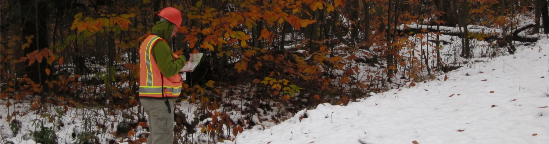
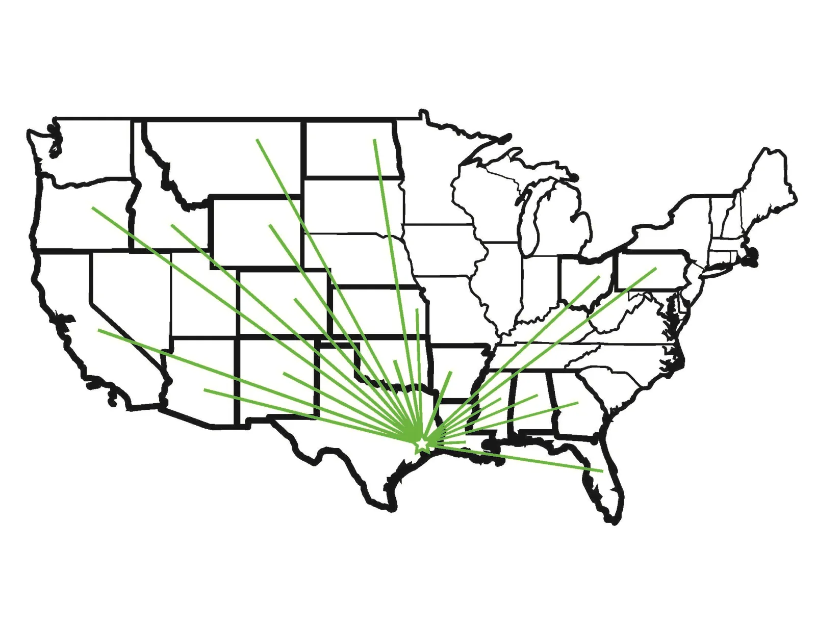 DESCO provides environmental consulting services, natural and cultural resources surveys, regulatory permitting and compliance, and a variety of other services to our clients across the continental United States. Below is a list of some representative projects conducted by DESCO. Please contact us for a comprehensive list of our capabilities or for additional information about our services or expertise.
Found 59 Projects
Rivers Edge 3D Texas
DESCO provided regulatory permitting and compliance monitoring services for a 97 square-mile 3D seismic survey project, which included portions of the Big Thicket National Preserve (BITH) and wetlands under the jurisdiction of the US Army Corps of Engineers (USACE). DESCO prepared a NEPA Environmental Assessment and conducted all resource surveys required by the National Park Service and USACE including T&E species surveys, wetland determinations, cultural resources surveys, and pre- and post-operational vegetation assessments of 17,000 acres within the Beaumont, Little Pine Island – Pine Island Bayou Corridor, Village Creek Corridor, and Lower Neches River Corridor units of the BITH. DESCO also provided biological and archeological monitor
Mitigation Bank Development: Wetland Delineation and USACE Approved Jurisdictional Determination (AJD) Support
DESCO conducted wetland delineations in accordance with US Army Corps of Engineers (USACE) guidelines in 4 separate Areas of Interest (AOIs), totaling 2,765 acres, for an environmental restoration, mitigation, and land management company based in Louisiana. The purpose of the delineation was to collect baseline data on wetlands in areas that will potentially be developed into mitigation banks. DESCO also provided support in obtaining AJDs for each of the 4 AOIs from the USACE.
Pipeline: BLM - NEPA Environmental Assessment
DESCO completed the NEPA Environmental Assessment for a pipeline project in Park County, WY. The lead federal agency for the project was the U.S. Bureau of Land Management, Cody Field Office. The Environmental Assessment included analysis of multiple alternatives to three proposed right-of-way grants for a 21-mile natural gas pipeline, a liquid hydrocarbon pipeline and associated permanent access roads. The project resulted in a Finding of No Significant Impact and rights-of-way were granted for each of the client’s three requests.
Pitcher Plant Bog Assessment: Big Thicket National Preserve
DESCO evaluated the existing hydrology, soils, and vegetation of the largest pitcher plant bog within the Big Thicket National Preserve in Tyler County, TX. This study was performed on behalf of the National Park Service to obtain a complete understanding of this ecotone, including its hydrology, soil regime, and vegetation composition, for future restoration and management efforts. DESCO examined and measured vegetation survival, density, and growth across four vegetation stratums: overstory (canopy), midstory, shrub, and herbaceous layers. DESCO provided a complete plant list in the report, including native bog species, other native species, and exotic/invasive species.
Crescent 3D Seismic Survey: Permitting and Environmental Support
DESCO completed the required permitting for surface access to St. Vrain State Park in Weld County, CO to allow a high-resolution 3D seismic survey to be conducted. This complex permitting effort required regular communication and coordination with multiple agencies, including the National Oceanic and Atmospheric Administration’s Real Property Management Division, the Colorado State Parks Department and the U.S. Bureau of Land Management.
South Nesson 3D Seismic Survey: Biological Evaluation and Aerial Raptor Nest Survey
DESCO completed biological surveys and permitting for a proposed 170-square-mile 3D seismic project that included lands managed by the U.S. Forest Service (McKenzie Ranger District, Little Missouri National Grasslands), the North Dakota Department of Game and Fish, and the U.S. Army Corps of Engineers. DESCO conducted aerial surveys to document the nesting status of previously mapped raptor nests and identify locations of undocumented nests. Acquired data were used to establish setbacks from active nests during seismic operations. To comply with U.S. Forest Service management plans, DESCO also completed a comprehensive Biological Assessment/Biological Evaluation analyzing project effects on 18 ESA- and U.S. Forest Service-listed species.
Wetland Delineation, Terrebonne Parish, LA
Conducted a wetland delineation on a 3.63 acre wooded tract being considered for a subdivision expansion project.
Seismic Monitoring, Sweet Lake, LA
Monitored seismic crew activities in marsh, swamp, and agricultural fields and advised equipment operators on least impact routes. Conducted impact assessments and made recommendations for remediation.
Environmental Monitoring, Grand Isle, LA
Monitored seismic related impacts to bird nesting colonies and habitat on beaches. Monitored crew activities around black mangrove stands in salt marshes and advised crew on least-impact equipment and routes. Conducted impact assessments and made recommendations for remediation.
Seismic Monitoring, Catahoula, LA
Monitored seismic crew activities near a catfish farm to ensure the feeding patterns and production of the fish were not affected by the detonation of charges in close proximity to the ponds. Conducted an impact assessment on a nearby crawfish pond that had been traversed by heavy equipment.
Lafourche Parish, LA
Conducted habitat assessments and comparisons from 1958 to present to determine land loss due to activities along a power line right of way. Developed remediation and mitigation plans to compensate for impacts.
Lower Rio Grande Valley National Wildlife Refuge/ El Paso Production, Willacy County, TX
Prepared a NEPA Environmental Assessment for a seismic survey on the Lower Rio Grande Valley National Wildlife Refuge, and monitored project activities on the Refuge to help minimize impacts.
Prairie Dog Surveys, Bureau of Land Management, Rawlins, WY
Located and mapped prairie dog towns in a seismic project area to determine if the habitat was conducive to black-footed ferret. Conducted raptor nest surveys to document activity. Identified potential mountain plover habitat.
Montgomery County, TX
Conducted a Phase I ESA in accordance with ASTM standards for a 140-acre residential property located in Magnolia, TX.
Turkey Creek Trail Project, Bryan, TX
Conducted waterbird rookery survey and threatened and endangered species survey for canebrake rattlesnake and Navasota lady’s tresses along and adjacent to a proposed trail route in accordance with agency permit stipulations.
Wetland Delineation and T and E Survey, Corpus Christi, TX
Conducted wetland delineation and threatened and endangered species survey along a pipeline right-of-way, in accordance with agency permit stipulations.
Morgan’s Point Resort Temple, TX
Prepared NEPA Environmental Assessment for a proposed wastewater treatment plant.
Biloxi Marsh Impact Assessment, Saint Bernard Parish, LA
Completed a comprehensive assessment of lines severely impacted by seismic operations. Measurements were taken of width and depth at 5-foot intervals along impacted portions of the receiver lines to document actual impacts resulting from the project. DESCO also identified areas of accelerated erosion that could have been attributed to seismic operations and calculated the area of each impacted zone. Summarized findings and results in a technical report for client and agency r
Well Pad Survey, Forest, MS
Conducted wildlife and vegetation survey of a well pad site within Bienville National Forest. Summarized findings and results in a technical report.
Water Wood National Resort, Point Blank, TX
Conducted Phase I ESAs, Preliminary CIR Wetland Interpretations, and Threaten, Endangered, Sensitive, and Rare Species surveys on over 3,000 acres for a golf course and adjacent properties in accordance with ASTM standards and requirements of the Endangered Species and Clean Water Acts.
Sheldon 3D, Eisenhower and Deussen Parks, Houston, TX
Performed compliance monitoring for a 3D seismic project in two City of Houston parks.
Shell Creek 3D Seismic Survey, Sweetwater County, WY and Moffat County, CO
Prepared a NEPA Environmental Assessment for a proposed 3D seismic project in cooperation with the Little Snake River Office of the Bureau of Land Management.
Transmission Line Support Services, St. Charles Parish, LA
Conducted pre- and post-environmental assessments of the reconstruction of a transmission line crossing the Bayou Des Allemands.
Triangle 3D Seismic Survey, Hardin County, TX
Obtained agency permits and conducted a threatened and endangered species survey for Texas trailing phlox.
Trinity River National Wildlife Refuge, Liberty County, TX
Prepared a NEPA Environmental Assessment and Hydrological and Geological Investigation for a seismic survey. Prepared a Plan of Operations for the subsequent 3D seismic operation on the Trinity River National Wildlife Refuge designed to minimize impacts to natural resources. Observed and guided equipment through surveying, drilling, and recording operations to ensure they were conducted in the least invasive manner possible.
Trinity Rural WSC, Trinity, TX
Performed services to support improvements to an existing water pipeline, water treatment facility, and elevated tank. Conducted wetland delineation in accordance with the USACE standards. Completed wildlife (red cockaded woodpecker and American bald eagle) and vegetation Surveys (Texas prairie dawn and Neches River rose mallow) in accordance with permit requirements and USFWS stipulations. Prepared report for submittal to USACE, USFWS, and Texas Water Improvement Board.
Wetland Mitigation Bank Support, Private Landowner, Lafourche Parish, LA
Developed proposal for the establishment of a mitigation bank on 150 to satisfy the regulatory requirements for compensatory mitigation of bottomland hardwood swamp and fresh marsh.
Wildlife and Vegetation Survey, Bienville National Forest, Forest, MS
Conducted wildlife (red cockaded woodpecker among others) and vegetation surveys for proposed endangered, threatened, and sensitive species in 3D seismic project overlap of Bienville National Forest. Identified approximately 1,050 individuals of Ashe hawthorn (Crataegus ashei) where less than 100 were previously known in the assumed range. Summarized findings and results in a technical report with maps of the project area.
Wind Dancer 3D Seismic Survey, Casper, WY
Conducted wildlife surveys (raptor nest and mountain plover) required by the Bureau of Land Management as part of the permitting process associated with 3D seismic operations.
3D Seismic Survey Assessment and Compliance Monitoring, St. Bernard Parish, LA
Conducted an assessment of a 3D seismic project area consisting of saline and brackish marsh, to document impacts resulting from a previous seismic operation. Provided monitoring and oversight of survey, drill, and recording crews conducting 3D seismic operations in salt, brackish, and fresh marsh environments. The project area encompassed the Biloxi Marsh Wildlife Management Area.
Biloxi Marsh Phase III 3D Seismic Survey, Saint Bernard Parish, LA
Provided monitoring and oversight services of survey, drill, and recording crews operating within a 153 square mile project area, which encompassed the Biloxi Marsh Wildlife Management Area. Identified and monitored bird rookeries marsh vegetation to minimize disturbance.
Biloxi Marsh Phase IV 3D Seismic Survey, Saint Bernard Parish, LA
Provided monitoring and oversight of survey, drill, and recording crews operating within a 150 square mile project area, which encompassed the Biloxi Marsh Wildlife Management Area. Identified and monitored bird rookeries and marsh vegetation to help minimize disturbance.
Bossier 3D, Homochitto National Forest, MS
Conducted biological surveys and wrote Biological Evaluation in accordance with permit requirements and USDA and USFWS stipulations. Summarized findings and results in a technical report including detailed geospatial analysis of sensitive resources. Completed USFWS required permitting and mapping for 2D seismic operations.
Caney Creek 3D, Monroe, LA
Conducted wildlife (red cockaded woodpecker and American bald eagle) and vegetation surveys (Southern lady’s slipper) in accordance with permit requirements and USFWS stipulations. Summarized findings and results in technical report. Completed permitting and geospatial analysis required by agencies for 3D seismic operations (USFWS, USACE, and Parish Councils).
Cherokee West 3D, WY and CO
Prepared a NEPA Environmental Assessment for a proposed 3D seismic project in cooperation with the Rawlins Field Office of the Bureau of Land Management. The project encompassed 135.6 square miles in Sweetwater County, Wyoming and Moffat County, Colorado.
Coffeepot 3D, CO
Prepared a NEPA Environmental Assessment for a proposed 3D seismic project in cooperation with the Little Snake River Office of the Bureau of Land Management. The project encompassed 27.2 square miles in Moffat County, Colorado.
Crosby 3D Seismic Survey, Harris County, TX
Obtained agency permits necessary to conduct 3D seismic operations.
East Gun Barrel 3D Seismic Survey, Casper, WY
Prepared a NEPA Environmental Assessment in cooperation with the Casper District of the Bureau of Land Management. Conducted wildlife surveys (raptor nest, sage grouse, and mountain plover) within the proposed project area in accordance with permit stipulations.
2D Seismic Survey, Big Thicket National Preserve, Beaumont, TX
Conducted monitoring of surveying and recording operations in the Lance Rosier and Little Pine Island Bayou Corridor Units of the Big Thicket National Preserve.
3D Seismic Monitoring, Highlands, TX
Observed and guided drilling and recording operations of a 3D seismic survey being conducted in and around the San Jacinto River under the jurisdiction of the Texas General Land Office. Conducted finfish impact assessments associated with detonation of charges.
3D Seismic Monitoring, Liberty/Chambers County, TX
Observed and guided surveying, drilling, and recording operations of a 3D seismic survey conducted in bottomland hardwood, cypress swamp, salt to intermediate marsh, fresh water lakes, and highland habitats to ensure compliance with stipulations and regulations set by the US Army Corps of Engineers. Conducted finfish impact assessments in conjunction with detonation of seismic charges.
3D Seismic Monitoring, Orange, TX & Anahuac, TX
Observed and guided drilling and recording operations of a 3D seismic survey being conducted in Sabine Lake under the jurisdiction of the Texas General Land Office. Conducted finfish impact assessments associated with detonation of charges.
3D Seismic Survey, Clark, WY
Prepared a NEPA Environmental Assessment for a proposed 3D seismic Project in cooperation with the Cody Field Office of the Bureau of Land Management.
3D Seismic Survey, Polk County TX
Completed agency permitting and archaeological services required for 3D seismic operations.
Archaeological Survey, Bienville National Forest, MS
Conducted an archaeological survey of the Bienville National Forest in association with BVRA and the Smith Co. 3D Seismic Survey. Provided project management services for twelve archaeology sub-contractors and coordinated with geophysical companies.
Banana Grove Developers, Lafourche Parish, LA
Conducted a wetland determinations on a 1500-acre tract of land being developed in to a golf course and residential community.
Regulatory Permitting, 3D Seismic Survey, St. Landry, St. Martin, and Lafayette Parishes, LA
Completed agency permitting and submitted maps required for 3D seismic operations to USFWS, USACE, and Parish Councils.
NW Oberlin 3D, Oberlin, LA
Conducted wildlife (red cockaded woodpecker) and vegetation surveys (American chaff-seed) in accordance with permit requirements and USFWS stipulations. Summarized findings and results in a technical report with maps of the project area. Completed agency permitting and submitted maps required for 3D seismic operations to USFWS, USACE, and Parish Councils.
Osbourne Springs 3D Seismic Survey, WY
Completed wildlife surveys in accordance with agency permit requirements.
Post Project Vegetation and Impact Assessment, Big Sandy Creek Unit, BTNP, TX
Completed a post-operational vegetation assessment of the Big Sandy Creek Unit of the BTNP to document impacts from a 3D seismic survey. DESCO compared pre- and post-project data from vegetation plots affected by the survey. This was the final phase of a three year project in the Big Thicket National Preserve.
Reed 3D, DeQunicy, LA
Conducted wildlife (red cockaded woodpecker, American bald eagle and colonial nesting bird rookeries) and vegetation surveys (long-sepaled false dragonhead, silveus dropseed, and barbed rattlesnake root) in accordance with permit requirements and USFWS stipulations. Completed geospatial analysis and summarized findings and results in a technical report. Completed agency permitting and generated maps required for 3D seismic operations for USFWS, USACE, and Parish Councils.
Sabine National Wildlife Refuge/Grant, Cameron Parish, LA
Observed and guided surveying, drilling, and recording operations of a 3D seismic survey being conducted in fresh and intermediate marsh in order to ensure that operations were conducted in the least invasive manner possible.
Sabine River 3D, Orange, TX
Performed finfish monitoring within waters managed by the state of Texas during detonation of explosives for 3D seismic project. Summarized findings and results in a technical report.
Laguna Madre Phase II, III, and Baffin Bay, TX
Monitored drill and recording crews on three consecutive projects to ensure compliance with restrictions/regulations of Padre Island National Seashore and the Texas General Land Office. Guided equipment through fragile environments, ensuring that least impact routes were followed. Assessed finfish impacts resulting from the firing of both air guns and dynamite.
Liberty 3D Seismic Survey, Liberty County, TX
Prepared a Plan of Operations for the Trinity River National Wildlife Refuge in accordance with permit requirements. Obtained agency permits and provided monitoring services to support 3D seismic operations.
Long Prairie 3D Seismic Survey, Newton, Jasper, and Orange Counties, TX
Obtained agency permits necessary to conduct 3D seismic operations.
Finfish Monitoring, Orange, TX
Performed finfish monitoring during bridge support structure demolition activities and prepared a finfish impact assessment for Texas Parks and Wildlife.
Hurricane Creek 3D Seismic Survey, Beauregard and Calcasieu Parishes, LA
Completed agency permitting and geospatial analysis required for 3D seismic operations for USFWS, USACE, and Parish Councils.
Knight Phase III 3D, Kountze, TX
Performed compliance monitoring of Hickory Creek Savanna and Village Creek Corridor Units of the Big Thicket National Preserve. Summarized findings and results in technical report.

